Application: mm2kml
Overview
mm2kml exports a georeferenced metric map (*.mm) as a Google Earth *.kmz file,
optionally together with the robot trajectory. It is a quick way to visually check the
quality of a map georeferencing against satellite imagery, and to produce fly-by videos of
maps.
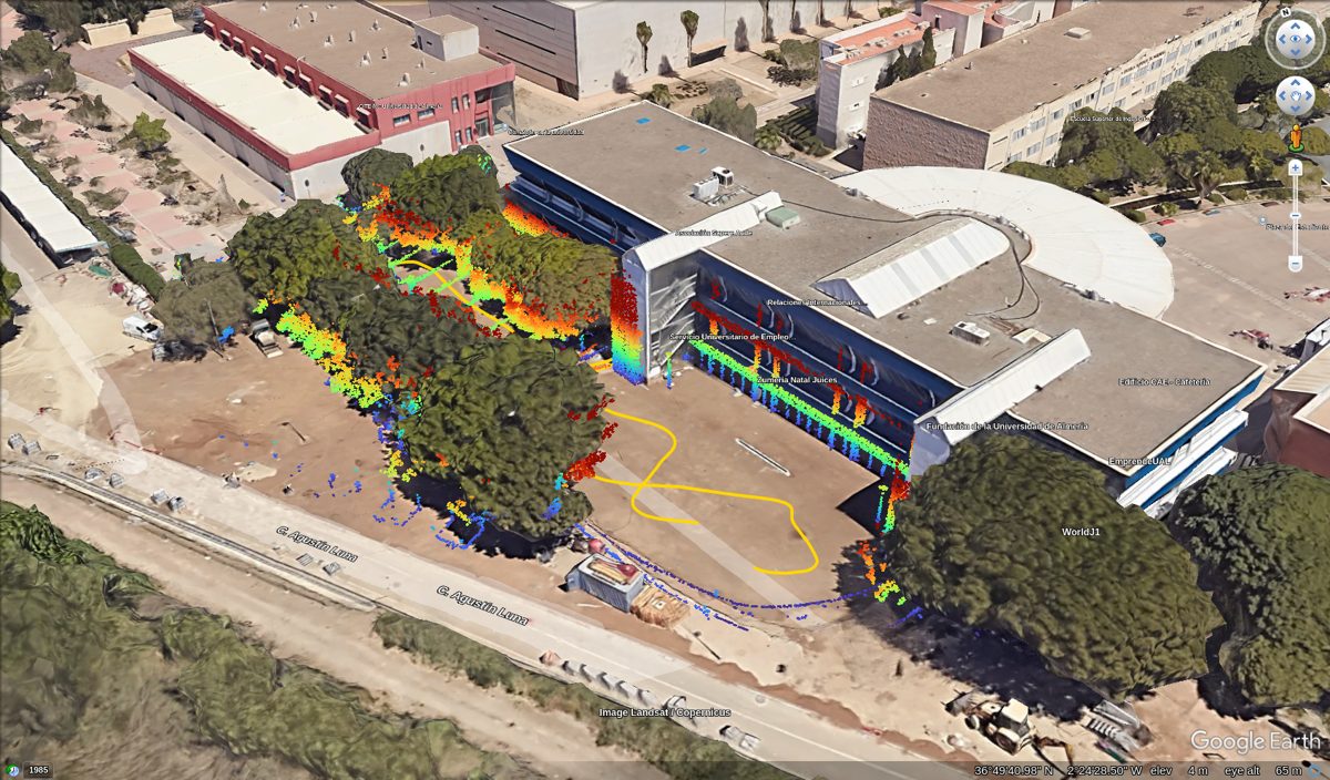
Example fly-by video, generated with the --tour-duration option:
The KMZ file contains:
Point cloud, 2D overlay: a top-down image of the point cloud (
GroundOverlay) draped on the terrain. It is light and always aligned with the imagery.Point cloud, 3D model: a COLLADA model with one small solid per point, after voxel decimation to keep Google Earth responsive. Points are colored by their height above the local ground.
Trajectory (optional): a line clamped to the ground.
Fly-by tour (optional): a
gx:Tourorbiting around the map.
Points close to the ground (--min-height-above-ground) are removed by default, so the
satellite imagery remains visible below walls, trees, poles, etc.
Point colors (--color-by) represent:
trajectory(default if a trajectory is given): the height relative to the nearest point of the trajectory. Since the reference follows the vehicle, colors keep the same meaning over large areas with changing elevation (e.g. objects at the height of the road are always blue), and it does not depend on observing the ground.ground(default without a trajectory): the height above the local ground, estimated as the lowest point in each cell of a--ground-cellgrid (and its 8 neighbors, to handle cells without ground returns). On steep slopes this underestimates the ground of the higher cells, so some ground points may remain (increase--min-height-above-ground).z: the ENU z coordinate, only useful for small, flat areas.
The color scale spans the 2% to 98% percentiles of these values, or --color-range.
Map layers whose classes are not point clouds but can provide one (e.g. keyframe-based maps
from mola_metric_maps, with --load-plugins) are also supported (MRPT >= 3.5.3).
Usage
Usage: mm2kml [OPTIONS] input

Positionals:
  input TEXT REQUIRED         Georeferenced metric map file (*.mm)

Options:
  -h,--help                   Print this help message and exit
  -o,--output TEXT REQUIRED   Output Google Earth file (*.kmz)
  -l,--layer TEXT ...         Point cloud layer to export. If not provided, all point cloud layers are merged. This argument can appear several times.
  -t,--trajectory TEXT        Optional trajectory file in TUM format, drawn as a line clamped to the ground. See --trajectory-frame.
  --trajectory-frame TEXT:{map,enu} [map]
                              Frame of the --trajectory poses: 'map' (the local frame of the input map) or 'enu' (East-North-Up, e.g. a trajectory already converted with the map georeferencing).
  --cloud TEXT:{both,overlay,model,none} [both]
                              How to export the point cloud: 'overlay' (top-down image draped on the terrain), 'model' (3D COLLADA model, one small solid per decimated point), 'both', or 'none'.
  --min-height-above-ground FLOAT [0.35]
                              Points lower than this height [m] above the local ground are not exported, so the satellite imagery remains visible. Use 0 to keep all points.
  --ground-cell FLOAT [1]     Cell size [m] of the grid used to estimate the local ground height.
  --color-by TEXT:{auto,ground,trajectory,z} [auto]
                              What the point colors represent: 'ground' (height above the local ground), 'trajectory' (height relative to the nearest trajectory point, best for large areas with changing elevation), 'z' (ENU z coordinate), or 'auto' ('trajectory' if a trajectory is given, 'ground' otherwise).
  --color-range FLOAT x 2     Values [m] mapped to the bottom and top of the color scale, e.g. '--color-range -2 10'. Default: the 2% and 98% percentiles of the point values.
  --overlay-resolution FLOAT  Ground overlay resolution [m/pixel]. Default (0): automatic, the finest one (>=5 cm) keeping the image under 2048 pixels.
  --model-max-points UINT [100000]
                              Maximum number of points in the 3D model. The cloud is voxel-decimated to fit.
  --model-point-size FLOAT    Size [m] of each point in the 3D model. Default (0): from the decimation voxel size.
  --model-altitude-offset FLOAT [0]
                              Extra altitude [m] for the 3D model, in case it does not sit on the terrain.
  --heading FLOAT [0]         Heading [deg] of the initial view.
  --tour-duration FLOAT       If >0, adds a 'Fly-by' tour [s] orbiting around the map. In Google Earth Pro, it can be recorded as a video with Tools > Movie Maker.
  --tour-tilt FLOAT [60]      Camera tilt [deg] for the fly-by tour.
  --load-plugins TEXT         One or more (comma separated) *.so files to load as plugins
Examples
Export a map built with MOLA, including its trajectory and a 40 s fly-by tour:
mm2kml map.mm -t trajectory.tum -o map.kmz --tour-duration 40
If the trajectory file is already in East-North-Up coordinates:
mm2kml map.mm -t trajectory_enu.tum --trajectory-frame enu -o map.kmz
Export only the light 2D overlay, e.g. for large maps:
mm2kml map.mm --cloud overlay -o map.kmz
Maps using custom map classes (e.g. from mola_metric_maps) need the plugin:
mm2kml map.mm -o map.kmz --load-plugins libmola_metric_maps.so
Notes
The input map must contain georeferencing information (see mm-georef).
Open the KMZ in Google Earth Pro (desktop) or Google Earth Web. Google Earth’s own “3D Buildings” layer (which also includes 3D trees) may hide the 2D overlay and parts of the 3D model. If it is disabled, keep in mind that the satellite imagery is flat: in tilted views, elevated points (e.g. tree canopies) appear shifted with respect to the objects in the imagery because of parallax. Enable “3D Buildings” to compare heights against Google 3D geometry.
The 3D model is placed so the ground below the map origin lies on Google Earth terrain. Use
--model-altitude-offsetto correct it if the model floats or sinks.Google Earth does not accept ground overlay images larger than 2048 pixels, hence the automatic resolution. For large maps, the overlay becomes coarser: crop the map first with mm-filter if more detail is needed.
To make a video of the fly-by: in Google Earth Pro, double-click the “Fly-by” tour in the Places panel to play it, or record it with Tools > Movie Maker.