Solutions
MOLA provides a modular set of solutions for LiDAR-based localization, mapping, and SLAM. All solutions are fully configurable via YAML - no recompilation needed.
See Plans and pricing for the comparison between Community (open-source) and Pro (commercial) editions.
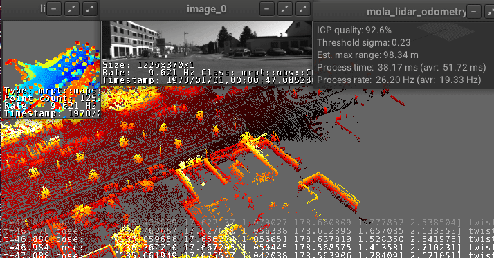
1. LiDAR odometry and localization (LO / LIO)
LiDAR odometry is one of the most advanced and flexible LiDAR odometry modules available. It supports:
LiDAR-only odometry (LO) - no IMU required
LiDAR-inertial odometry (LIO) - fusing LiDAR with IMU for improved robustness
Both modes work in mapping (build a map from scratch) and localization (localize within a prebuilt map) configurations.
Key strengths: Sub-centimeter accuracy when tuned for survey-grade applications, or lightweight real-time performance for navigation. Configurable pipeline via YAML.
Get started: Build your first map | Mapping and localization tutorial | Ouster LIO tutorial
2. Fused localization: LO/LIO + GNSS + kinematics
Based on the smoother state estimator, this solution improves localization in a prebuilt map by fusing:
LiDAR odometry output (LO or LIO)
GNSS (consumer-grade GPS receivers)
Kinematics (wheel encoders, vehicle odometry)
IMU data
This multi-sensor fusion provides robust, drift-corrected localization suitable for autonomous navigation in both indoor and outdoor environments. The smoother handles sensor outages gracefully - if GNSS signal is lost indoors, LiDAR odometry continues seamlessly.
Best for: Autonomous mobile robots (AMR), outdoor vehicles transitioning between GPS-available and GPS-denied areas, mixed indoor-outdoor scenarios.
3. Map-less georeferenced localization
Based on the smoother state estimator, this solution provides RTK-quality georeferenced pose estimation without a prebuilt map.
By fusing low-cost GNSS + LiDAR + IMU + kinematics, the smoother estimates the vehicle pose in geodetic (latitude/longitude) or UTM coordinates in real time. No RTK base station is required - a standard consumer-grade GNSS receiver is sufficient.
This enables:
Outdoor robot navigation with absolute positioning from the first second
Georeferenced trajectory logging for fleet management
Autonomous driving in open environments without prior mapping
Best for: Agricultural robots, autonomous tractors, outdoor inspection platforms, delivery robots, and any application requiring absolute outdoor positioning without the cost and complexity of RTK infrastructure.
4. Full 3D SLAM (georeferencing + loop closure)
Build globally consistent, georeferenced 3D maps, even in large-scale environments mixing indoor and outdoor areas. This is the most complete SLAM solution in MOLA, combining:
Georeferencing metric maps with consumer-grade GNSS sensors (see Georeferencing)
Offline loop closure for globally consistent maps - corrects accumulated drift over long trajectories
Simple-map → metric-map pipelines for flexible post-processing (see sm2mm pipelines)
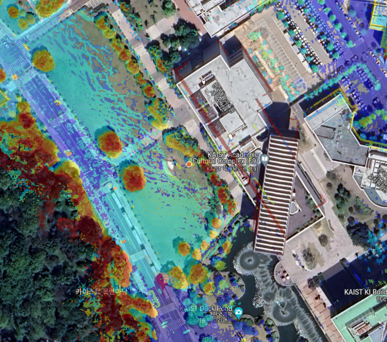
Best for: Large-scale surveying, building 3D maps of campuses/cities, creating reference maps for localization.
Coming soon:
mola_3d_mapper: Full live/offline 3D SLAM with online loop closure (in development)mola_2d_mapper: 2D SLAM via pose graph optimization for 2D LiDARs (in development)
Industry applications
Autonomous Mobile Robots (AMR)
Warehouse logistics, cleaning robots, inspection platforms. Real-time LO/LIO for navigation and prebuilt-map localization for autonomous operation.
Agriculture & Greenhouses
Autonomous tractors, greenhouse navigation, crop monitoring, and precision agriculture. Validated on the GreenBot dataset in Mediterranean greenhouse environments.
Automotive & ADAS
Urban autonomous driving and HD map generation. Benchmarked on KITTI with 0.6% translation error. Compatible with standard automotive sensor suites (LiDAR + IMU + GNSS).
Surveying & 3D Scanning
Backpack mapping, drone-based surveying, forest inventory. Export to LAS/PLY for GIS workflows. Sub-centimeter accuracy with survey-grade pipeline tuning.
Inspection
Industrial facility inspection, infrastructure monitoring, underground and mining environments. Works with handheld, backpack, and drone-mounted LiDARs.
Indoor Mapping
Building interiors, warehouses, offices. Create detailed 3D maps for facility management, renovation planning, or robot navigation.
Demos and videos
More demos on the MOLA YouTube playlist →